DRAFT
- 1547-1559 嘉靖24至38 大明輿地圖 廣東輿圖
- 1595 粵大記 萬曆本 郭棐 廣東沿海圖 香港 鯉魚門 赤柱 黃泥埇 大潭 稍箕灣
- 1581 萬曆9 蒼梧總督軍門志 全廣海圖
- 1621 天啟元 武備志 鄭和航海圖 佛堂門 官富寨 大嶼山
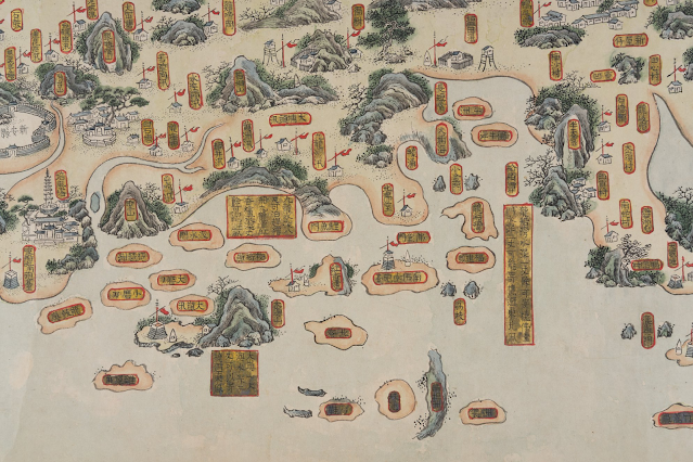
- 1685 康煕24 《廣東輿圖》 新安 官富山 佛堂門 大奚山 獨鰲洋 合連海 杯渡山
- 1688 康熙27 《新安縣志》 南北佛堂 官富山 獨鰲洋 急水門
- 1693-1722 康熙末年 皇輿全覽分省圖 大帽山 官富山 急水門 大澳 杯渡
- 1708–1718 康熙47至57 康熙皇輿全覽圖 官富山 急水門 杯渡 磨刀 大澳 大帽山
- 1730 雍正8 陳倫炯 《海國聞見錄 ‧ 沿海全圖》 1793 (no name)
- 清中至晚期 南中國海岸圖卷 Gallica of Bibliothèque nationale de France 鯉魚門 九龍汛 將軍澳 紅香爐山 團門
- 1746-1749 Carl Johan Gethe's Itinerary Book Kept During the Journey to East India, from October 18, 1746 to June 20, 1749. Image 212 showing Lantao and Macao
- 1760 Carte d'une partie des côtes de la Chine et des îles adjacentes... earliest use of the name Fanchin chow 泛春洲 Hong Kong Maritime Museum 1771 1775 no name
- 1778 A Chart of the China Sea from the Island of Sanciam to Pedrabranca with the course of the river Tigris from Canton to Macao. Po-ke-long Point=Lei Yue Mun Point. 1780 Ref.: Henry D. Talbot's "A British Maritime Chart of 1780 Showing Hong Kong," Journal of the Hong Kong Branch of the Royal Asiatic Society, Vol. 10 (1970), pp. 128-133
- Early 19th century 福建廣東海防航海圖 (Fujian Guangdong Coastal Defence Navigation Chart) in Hong Kong Maritime Museum on Google Art and Culture
- Daniel Ross_This chart of the different passages leading to Macao Roads 1810 Hong Kong 紅江
- 1814 Chart of the coast of China to the eastward of the great Ladrone no name Cow-loon
- Post-1815 廣東通省水道圖 no name
- 1816-1832 廣東全省經緯地輿圖 no name
- 1819 嘉慶24 新安縣志 新安志圖:鯉魚門炮台 卷四:「鷄婆山在九寨東南,怪石嶙峋。昔土冦李萬榮駐此,以掠商舶。」「鯉魚門在官富山南。」
- Pre-1820 廣州府新安縣水陸塘汛輿圖 no name 大埔 元朗 屯門
- 1822 廣東通志 卷83 新安縣圖
- 1831 Chart of Choo Keang or Canton River by James Horsburgh 1833 1847
- 1834 Die Chinesische Küste der Provinz Kuang-tung, zu beiden Seiten des Meridians von Macao Ly-i-mun
- 1838 廣東海防彙覽
- pre-1839 廣東沿海統屬圖 in Hong Kong Maritime Museum on Google Art and Culture
- Treaty map 1841 (surveyed by Captain Sir Edward Belcher
- MPK 1.148 Hong Kong Surveyed by Captn. Sir Edward Belcher H.M. Surveying Ship Sulphur,1841_1843-1895
- PH64.001 Hong Kong Map 1844 Henry Colburn of Marlborough Street, London 26 x 20 cm
- MAP000134 The ordnance map of Hong Kong 1845 Southampton] [Board of Ordnance
- 1846 The Lyeemoon from Hong Kong side (Hong Kong. Royal Engineers' Office)
- 1846 The Lyeemoon from the Highest Peak Hong Kong (Mount Parker) (Hong Kong. Royal Engineers' Office)
- 1846 The Lyemoon from the outside (Hong Kong. Royal Engineers' Office)
- 1846 The Lyeemoon from the Chinese side (Hong Kong. Royal Engineers' Office)
- HONG KONG &C. AS SEEN FROM THE ANCHORAGE by Lieutenant (later Admiral) Leopold Heath in 1846 and published in 1847. Taken from a vantage point aboard HMS Iris anchored centrally in the harbour they combine to form an overlapping 360 degree panorama of the harbour. Hong Kong--Heath, Leopold G_Hong Kong &c. as seen from the anchorage
- The Ordnance Map of Hong Kong by Lieut. Collinson 1846
- Treaty map, Beijing Treaty 1860
- 1861 Oostkust van China: van Pingyang Punt tot Macao Lyemoen passage
- 1864 廣東全圖 湖北官書局編制 1864 廣東全圖 同治三年 1864 大澳 大帽山 杯渡山 no name
- 1866 Map of the San-On District Simeone Volonteri NLA
- 1870-1871 廣東圖說 毛鴻賓 桂文燦 萃文堂 同治9-10 新安縣圖
- 1879 Map of the Province of Canton according to the map of the Kwong-Tung tʻu shot
- Digital Commonwealth_Channels to Hong Kong and Macao 1877 Compiled by James F. Imray, F. R. G. S.
- 1881 七省沿海全圖 七省沿海圖 (no name)
- 1884 Kantō-shō Chōshū-fu yori Renshū-fu ni itaru 《自廣東省惠州府博羅縣東至同海豐縣沿道略圖》 香港 九龍塞 油麻地 造船所 沙田
- Channel to Hong Kong and Macao 1885
- 1887 廣東全省水陸輿圖 (no name)
- 1891 清朝柔遠記
- 1896 皇朝直省輿地全圖
- 1897 廣東輿地全圖
- Map attached to The Convention for the Extension of Hong Kong Territory, 1898
- 1899 HK MPG 1-796 CO 700 Sketch map showing southern part of Kwangtung Province and Hong Kong
- Map of the Hongkong and Lilong mission areas. Dilger, J. 1905 - 1914
- Map of the colony of Hong Kong 1907
- Map of Hong Kong and New Leased Territory 1911 Chatham
- MAP000138 Hong Kong (Sheet 5) War Office 1922 70 x 105 cm
- MAP030031 Hong Kong and the New Territories_War Office 1936 74 x 100 cm
- Battle progress outline map of fighting for capture of Hong Kong 香港攻略戰戰鬥經過要圖
- National Institute for Defense Studies_Battle progress outline drawing of fighting for capture of Kowloon peninsula 九龍半島攻略
- Hong Kong, 1948 ANU
- Hong Kong Surveyed by Captn. Sir E. Belcher 1843 (Major Corrections to 1953) 2
- Hong Kong and the New Territories 1957 ANU
- Detailed War Office and Air Ministry Two-Sheet Chart of Hong Kong 1958 2
- Hong Kong, Jan Jan's Map of Hong Kong, 1958 ANU
- Map of Hong Kong Kowloon and the New Territories 1960 1
- Hong Kong, Population Distribution In the Urban Area of Hong Kong, 1967
- Hong Kong, The Functional Land Use in the Urban Area of Hong Kong, 1967
- Hong Kong, Distribution of Population in Hong Kong, 1967
- Hong Kong, Population Density In the Urban Area of Hong Kong, 1967
- MAP000121 Hong Kong, Kowloon and the New Territories (Sheet 2) 1974 Crown Lands and Survey Office 100.8 x 76.2 cm


.jpg)
.jpg)


No comments:
Post a Comment